
I am going to study Camber Sands and Fairlight to see if the hypothesis that I am investigating is true, the hypothesis is: "Coastal management is more effective at Fairlight than at Camber".
Contents Page Introduction 3 Data Collection & Recording 5 Data Presentation 9 Data Analysis 40 Conclusion & Evaluation 47 Bibliography 49 Introduction I am going to study Camber Sands and Fairlight to see if the hypothesis that I am investigating is true, the hypothesis is: "Coastal management is more effective at Fairlight than at Camber". I will use different types of equipment and many skills to present my findings in graphs, tables and various other means. The two sites that I am investigating are located in East Sussex, on the South East coast of England; I have included a sketch map below to show their locations. I have circled Cliff End, as this is the exact location where I collected my data. The beach at Camber (known as Camber Sands) has been a major tourist attraction for many years, but would not be so successful if it wasn't for the schemes that managers of this coastline have put in place. The dunes at Camber are held in place with the help of marram grass, which grows on top of the sand with long roots helping to keep the surface together. Also the blades of the marram grass catch the sand to stop it from blowing back down the beach towards the sea. Dunes form where large stretches of sand are exposed at low tide and is moved up the beach by the wind as well as the process of

The Social Costs and Benefits of A Business Activity - Paddington Basin
2 THE SOCIAL COSTS AND BENEFITS OF A BUSINESS ACTIVITY - PADDINGTON BASIN INTRODUCTION 4 2 PRESENTATION 5 2.1 NOTES 5 2.2 NOTES AFTER MEETING 5 2.2.1 LOCAL COUNCIL 5 2.2.2 LOCAL BUSINESSES 5 2.2.3 RESIDENTS 6 2.2.4 NWC SCHOOL 6 3 STAKEHOLDERS 7 3.1 LOCAL COUNCIL 7 3.1.1 SOCIAL BENEFITS 7 3.1.2 SOCIAL COSTS 7 3.2 LOCAL BUSINESSES 7 3.2.1 SOCIAL BENEFITS 7 3.2.2 SOCIAL COSTS 7 3.3 LOCAL RESIDENTS 8 3.3.1 SOCIAL BENEFITS 8 3.3.2 SOCIAL COSTS 8 3.4 NWC SCHOOL 8 3.4.1 SOCIAL BENEFITS 8 3.4.2 SOCIAL COSTS 8 3.5 SUMMARY 8 4 ENVIRONMENTAL COSTS AND BENEFITS 9 4.1 PRESSURE GROUPS 9 5 ENVIRONMENTAL LEGISLATION 10 5.1 ENVIRONMENTAL PROTECTION ACT 1990 10 5.2 PLANNING ACT 10 MEETING 11 5.3 NOTES 11 5.4 NOTES AFTER MEETING 12 5.4.1 COUNCIL 12 5.4.2 RESIDENTS 12 5.4.3 BUSINESSES 12 5.4.4 NWCS 12 5.4.5 CHANGES 12 6 ARTICLE 13 7 PUBLIC MEETING 15 7.1 COUNCIL'S VIEWS 15 7.2 RESIDENT'S VIEWS 15 7.3 BUSINESSES VIEWS 15 7.4 NWCS VIEWS 15 7.5 FUTURE CHANGES 15 7.6 IMPACT 16 8 ENVIRONMENTAL IMPROVEMENTS 16 9 RECOMMENDATIONS 17 9.1 ECONOMIC GROWTH 17 9.2 SOCIAL INVESTMENT 17 9.3 EMPLOYMENT 17 9.4 HOUSING QUALITY 17 9.5 TRANSPORT 17 9.6 WATER QUALITY 18 9.7 LAND USE 18 9.8 SUITABILITY 18 0 SOURCES OF INFORMATION 19 0.1 SOURCE 1 20 0.2 SOURCE 2 20 0.3 SOURCE 3 20 Report Social Costs & Benefits - Paddington Basin To:
Opportunities in the big emerging markets (BEMs) such as India, Brazil and China.
Table of contents Table of contents 1 INTRODUCTION 2 People's Republic of China 2 The manufacturing sector 4 The transportation framework 5 ? Mode of transport used 5 ? Problems in road transport 5 ? Firms' actions to minimize problems 7 DISTRIBUTION 8 ? Important success factor 8 In China the relationship is (nearly) everything 9 ? Interaction of guanxi approaches 9 The effectiveness 9 Initial contact 10 Planning a China strategy 10 Investing in China is a long game, not a way to quick profits 11 RECCOMANDATION 12 SHENZHEN 12 Special Economic Zones 12 Shenzhen's Favorable Policies 12 Shenzhen's Strategic Location 13 Opportunities in telecom industry 13 APPENDIX 14 . Manufacturing sector ratios 14 2. China's seven regional marketstci 19 References 27 INTRODUCTION As social and economic events bring about unraveling opportunities in the big emerging markets (BEMs) such as India, Brazil and China, many multinational corporations (MNCs) have made substantial investment in these countries as an integral part of their global expansion strategies (Garten, 1998). Selecting among alternative international markets, be it for exporting, licensing, joint ventures, strategic alliances or direct investment, requires information. Likewise, the assessment of information across different types of markets determines, in large part, the degree of success (or
Herne Bay is situated along the stretch of the North Kent coast in Southeast. I choose to study this site because there are many different measures taken for coastal protection.
Introduction Herne Bay is situated along the stretch of the North Kent coast in Southeast. I choose to study this site because there are many different measures taken for coastal protection. I can get a broader range of results ending in a more accurate conclusion of the situation. The specific topic I have chosen to study is how and why do cliff and beach profiles vary along the stretch of the north Kent coast. I believe that the most well protected areas of the coast that I will study are likely to have the largest pebbles, the longest and the most level beaches. In the areas with little or no protection pebbles will be smaller if not be shingle and perhaps sand in some areas. The cliffs are also likely to be cut away from the bottom leaving them unstable and in some conditions causing slumping. It was decided after the storm of 1953, which caused disastrous flooding and wide spread destruction that Herne bay needed new improved sea defences. After some research into the matter by the local district council it was discovered that a storm of the same magnitude would return in an estimated period of a hundred years. When strong winds gather in the northern sea a factor known as the North Sea surge occurs at which time the sea level can raise up to two metres above the level of the normal waters which is what caused the catastrophic flooding in the storm of 1953. Previous
![Volcanic and seismic events are major pieces of evidence towards proving that plate-tectonics theory is valid Discuss the extent to which you agree with this statement. [40 marks]](https://mbt-essays-prod-public.s3.eu-west-1.amazonaws.com/1201436/listing/1201436_1.jpg)
Volcanic and seismic events are major pieces of evidence towards proving that plate-tectonics theory is valid Discuss the extent to which you agree with this statement. [40 marks]
“Volcanic and seismic events are major pieces of evidence towards proving that plate-tectonics theory is valid” Discuss the extent to which you agree with this statement. [40 marks] Definition 1. This approach turned out to be plate tectonics—the theory that the continents are carried along on huge slabs, or plates, of the Earth’s outermost layer. In other places plates have been slowly converging, forming compressional features like huge mountain ranges. In other places plates have been moving apart, forming expansional features like the great rift valleys. The theory of plate tectonics provided, for the first time, a coherent, unified explanation for all of these features of the Earth’s surface. Continental drift – Jigsaw model 1. In 1910, Alfred Wegener began lecturing and writing scientific papers about continental drift. The continental drift hypothesis suggested that the continents have not always been in their present locations but instead have “drifted” and changed positions. Wegener’s idea was that the continents had once been joined together in a single “supercontinent,” which he called Pangaea (pronounced PanJEE-ah), meaning “all lands” (Fig. 4.1). He suggested that Pangaea had split into fragments like pieces of ice floating on a pond and that the continental fragments had slowly drifted to their present locations. But Wegeners main

Hydrology and Fluvial geomorphology. (Q&A)
HYDROLOGY AND FLUVIAL GEOMORPHOLOGY Q: "Human activity, climate and landscape all affect a rivers regime". Discuss with reference to rivers from around the world. Suggested Answer The river regime is the expected seasonal pattern of discharge at a given point, over a year. The discharge is the amount of water flowing in the river channel. It is calculated by multiplying the cross-sectional area by the mean velocity (speed). A river's regime is based on average monthly discharge figures. These are collected over at least 20 years to try to eliminate minor year-to-year variations. There are several factors which will affect the river's regime, including rainfall, temperature, human use of the land and the landscape. For a better answer it is suggested that each of the factors has to be explained with examples using named rivers how each one may affect the regime of the river. Factors affect the regime Human activity means 'how people use the river and the surrounding land'. For example, if vast amounts of water are taken out of the river by industry, this may affect the regime as it will artificially decrease the amount of water in the river (although most industries do return the 'used' water to the river channel). In a similar way, if large amounts of water are used for agricultural irrigation, or water is removed from the river and directed somewhere else, the
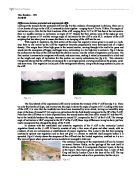
Differences between protected and unprotected cliffs
Analysis Differences between protected and unprotected cliffs Looking at the transect for the protected cliff (see fig 3:4) the evidence of management is obvious. There are in all six breaks of slope in the cliff, all reasonably close together - ranging from 4.13m to 11.86m. The angles of inclination vary a little for the first 6 sections of the cliff, ranging from 13.5º to 20º but then at the last section there is a sudden increase in inclination, an angle of 31º. Despite the final section, none of the angles go over the angle of repose at 35º and the average angle of inclination for the cliff is only 20.2º, evidence of the cliff sculpting that has taken place to ensure that there is no slumping of the cliff into the sea. With regard to vegetation, the first section of the slope has regularly mown grass as is used as a walk-way, then as one moves up the cliff the vegetation becomes progressively more developed and of a higher density. This ranges from 50cm high grass in the second section, moving through taller and taller grass and weeds into the emergence of bigger and bigger trees, culminating in a 4m high tree in section 6. Fig 4:1 shows the walkway at the base of the cliff and then the shallow incline, also the extent of vegetation can be seen. The final section is extensively overgrown with scrub, and some trees, making it virtually inaccessible to climb and so
"Can the theories that Alfred D. Chandler developed in his book 'Scale and Scope: The dynamics of industrial capitalism' be applied to patterns of economic growth in the second half of the 20th century?"
TABLE OF CONTENTS . Introduction 1 2. Chandler's theory 1 3. Methodology and selection of study objects 3 4. Description of developments 4 Country level 4 Industry level 5 Firm level 6 5. Compare these patterns to Chandler's predictions 6 Country level 6 Industry and firm level 8 6. Future growth industries 9 7. Conclusion 10 Reference List 11 Appendix A - 900 largest German firms 12 Appendix B - Growth industries in the USA 16 Appendix C - selected GDPs in 1950 17 . INTRODUCTION "Scale and Scope: The dynamics of industrial capitalism" (henceforth Scale and Scope) by Alfred D. Chandler (1990) is one of the central books in economic history. Like only few books, it explains many economic developments in the period from the 1880s until deep into the 20th century. By focusing on this period, the period of the so-called second industrial revolution, Chandler investigates a period with immense changes in business and economic environment. Therefore, even though the period is time wise relatively narrow, it still provides enough evidence to develop strong theories. The book develops theories that have a strong explanatory power for the period under review. Because the book does not scrutinize events and developments that occurred in the times that followed, one might naturally wonder in how far the ideas developed by Chandler can be transferred into our post-modern

Does the river Alyn follow Bradshaw's model?
Does the river Alyn follow Bradshaw's model? Introduction What is Bradshaw's model? The hydraulic geometry of rivers varies throughout their course. Bradshaw's model is a general model for how different river variables change downstream. Below is a diagram showing Bradshaw's model. Aim of my investigation The aim of my investigation is to see how the river variables change on the river Alyn and how this compares to Bradshaw's model in terms of 2 key questions: * How the velocity of the river Alyn changes along the profile? * How the Discharge of the river Alyn changes along the profile? Hypothesis Following Bradshaw's model I would expect both the river velocity and discharge to increase the further you travel downstream. Theory Velocity is the speed that the water is moving. It is measured in metres per second. The theory behind velocity increasing downstream is that it depends on 3 factors: Channel Gradient, Channel Roughness and Channel Shape. * Channel Gradient - Due to gravity the greater the channel slope the greater the velocity if other factors remain constant. * Channel Roughness - The rougher the channel is (how many rocks and boulders are found in the river channel) the more obstacles there are opposing the waters flow leading to increased friction and decreased velocity. The channel is less rough the further you go downstream and so the river flows

TOURISM'S THREE MAIN IMPACT AREAS
TOURISM'S THREE MAIN IMPACT AREAS * Three main impact areas: natural resources, pollution, physical impacts * Environmental impacts at the global level * Other industry impacts on tourism * How tourism can contribute to environmental conservation Negative impacts from tourism occur when the level of visitor use is greater than the environment's ability to cope with this use within the acceptable limits of change. Uncontrolled conventional tourism poses potential threats to many natural areas around the world. It can put enormous pressure on an area and lead to impacts such as soil erosion, increased pollution, discharges into the sea, natural habitat loss, increased pressure on endangered species and heightened vulnerability to forest fires. It often puts a strain on water resources, and it can force local populations to compete for the use of critical resources. DEPLETION OF NATURAL RESOURCES Tourism development can put pressure on natural resources when it increases consumption in areas where resources are already scarce. Water resources Water, and especially fresh water, is one of the most critical natural resources. The tourism industry generally overuses water resources for hotels, swimming pools, golf courses and personal use of water by tourists. This can result in water shortages and degradation of water supplies, as well as generating a greater volume of


