
Kobe, Japan (Case Study)
Kobe, Japan (Case Study) Japan is positioned on the margin of the Eurasian Plate. The Philippine Sea Plate is subducted below the Eurasian plate, resulting in Japan having greater than average seismic and volcanic activity. Immediately south of Osaka Bay is a fault called the Median Tectonic Line, and it was sudden movement along this fault that triggered the earthquake that hit Kobe. Kobe is located farther than many other cities in Japan from the dangerous intersection of three tectonic plates: the Pacific, Eurasian, and Philippine. This triple junction is a junction of three compressive subduction zones. There had been a subduction fault that had already been broken in great earthquakes in 1944 and 1946. Kobe is also somewhat off the Median Tectonic Line, a zone of strike-slip faults. At 5.46am on January 17th 1995, whilst many of its people of Kobe were still asleep, the Japanese city of was hit by the largest earthquake in Japan since 1923. The earthquake was not only powerful (Richter scale 6.9 ), but with the epicenter only 20km southwest of the city, it resulted in massive damage to property and loss of life. The worst effected area was in the central part of Kobe, a region about 5km by 20km alongside the main docks and port area. This area is built on soft and easily moved rocks, especially the port itself which is built on reclaimed ground. Here the ground

Investigate the rate of which lava flows down the side of a volcano and what affects the rate of which it flows.
Lava Flow Aim My aim is to investigate the rate of which lava flows down the side of a volcano and what affects the rate of which it flows. Planning In this investigation there are many different variables these are; * Angle of slope * Surface of volcano * The amount of lava * The temperature of the lava * The environmental conditions * The viscosity of the lava * How far it has to flow * The force of the eruption I have decided to investigate the angle of the slope because I will be doing the investigation in a school lab. So I will not be able to use real lava or a real volcano so I will use golden syrup instead of lava and a tile instead of a volcano slope. I also think that it will be easiest to set up and get accurate results. I predict that the higher the angle of the slope the faster the lava will flow down the slope. I have made this prediction from my scientific knowledge. I think this because the higher the angle gets the more gravitational potential energy (GPE) will be acting on the lava. So what is GPE well it is a type of energy that is stored in an object because of its height through which it has been lifted against the force of gravity. If it falls down we know that it has got gravitational potential energy. So it will be forced down the slope at a higher force. GPE is linked to kinetic energy. GPE that is acting on the lava can make it move
Limestone and it history
Limestone The formation of limestone Lime stone is a sedimentary rock made of dead animal shells formed deep down in the ocean; limestone also contains a large amount of calcium carbonate. Carboniferous limestone is a different type of limestone. It was formed around 350,000,000 years ago as a marine deposit in a warm, clear, shallow sea. The rock is well bedded and jointed. The cracks that separate the beds are called bedding planes and those that run down through the rock are called joints. Chalk is also a type of soft porous white limestone. Chalk is found mostly in England, a good example of this is the white cliffs of Dover or the motorway cutting at Blue Bell Hill, in Kent. Erosion and weathering Scree: lime stone tends to erode along the joints due to freeze thaw, this causes the parts to break off and fall to the bottom of the rock face to join the rest of the scree. Terraces: Limestone terraces are exposed bedding planes. Terraces are formed when limestone is eroded along joints and bedding planes on the scarp slope. Blocks of limestone are removed leaving the terracing. Limestone pavements: Where limestone outcrops at the top a hill, limestone pavements will form. The surface of the pavement is an exposed bedding plane and the exposed joints become widened, to form grykes, the blocks of limestone that remain between the grykes are called clints. Acidic

Creative writing - I, David Vivian-Currie, had been used to the upper-class life until I was forced to join the war through National Service.
I, David Vivian-Currie, had been used to the upper-class life until I was forced to join the war through National Service. I had received the dreaded letter on 29th May 1944, a week before it detailed me to leave. I was to help recapture France from the German's. Until I had received the letter, I felt that I had lived quite a pleasant life: I had attended Dunce Hall in North London and, at the age of thirteen, had moved onto Eton, where I became a school prefect in my final year. My father, John Vivian-Currie, was a well-established banker who had always tried to give me the best opportunities in life. After realising his success in banking, I decided to give it a try after I left Eton, and by the age of twenty-five, I had risen to the position of my father's assistant. He had avoided National Service due to age reasons. I however, had not. Due to my schooling I entered the army as captain, so I was in a better position that most of the soldiers. However, I still knew that I had virtually no chance of surviving. Today, 5th June 1944, I was sitting in the tiny transport boat with the remainder of my platoon, preparing ourselves for the journey to France, that would decide the rest of our lives. There was not a cloud in the sky, however, it was still quite brisk, I was glad that I had decided to put an extra pair of breeches on, but it didn't really matter, for I would

glacial eroded landforms
June 2002 - past paper (1) . Distinguish between the processes of erosion and weathering in an area undergoing glaciation. Erosion is the wearing away and removal of material by a moving force. In an area undergoing glaciation the moving force is the ice. The processes of erosion include plucking and abrasion. On the other hand weathering is the breakdown and decay of rock in situ, with no movement involved. The processes of weathering include freeze-thaw and dilatation. Erosion moves rocks from one place to another, whereas weathering simply breaks rock particles down. So the difference between the processes of erosion and weathering it that the processes of erosion involve movement, whereas the processes of weathering do not. 2. Examine the impact of glacially eroded landforms on human activity Glacially eroded landforms have many different impacts on human activity, some positive and some negative. These impacts range from transport to industry in both rural and urban areas. Transport is an aspect of human activity affected by glacially eroded landforms. U shaped valleys are glacially eroded landforms which have great advantages for transport as they provide natural routeways for through upland areas. So roads and railway lines can be constructed, linking major towns together. For example the A591, which is the main road through the Lake District, follows a glacial
Extreme Weather Investigation
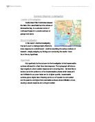
Extreme Weather Investigation Location of Investigation Castle Head Field Centre lies between the fells of the Lake District and the shores of Morecambe Bay, in a secluded corner of northwest England in a small rural town of grange over sands. Aim of Investigation In this report I shall be investigating how land-use in a drainage basin affects the rivers response to a rainfall event. I shall be describing the various methods of research, deeply analysing my findings and concluding the results I have found the my hypothesis. Hypothesis My hypothesis for the outcome for the investigation is that impermeable surfaces will result in a flash flood river response. The hydrograph will show a high magnitude, short duration response and a short lag time. I believe this to be true due to the surface run off on impermeable surfaces which because it can't infiltrate it runs down faster and in a higher quantity. Impermeable surfaces give a higher risk of flooding as the run off duration is a lot quicker and the peak is a lot higher than permeable surfaces where infiltration occurs causing a slower response and a longer duration. Method Part 1: Simulating Drainage Basins The investigation was based around four different surface types representing drainage basins, to test the response of each surface. The first surface was bare earth witch consisted of various materials including
Upper Porter Valley in Sheffield - source related study.
History Around Us By Philip Jacobs Introduction On Tuesday 10th June 2003 and Wednesday 18th June 2003 I visited the upper Porter Valley in Sheffield. The purpose of these visits was to give me an understanding and provide evidence to aid me in answering the following questions. a) Would your visit to Shepherd Wheel give you enough evidence to support what is said in Sources A, B and C? b) Consider all the sites you have visited to help you answer the following question b) i) How useful are the various sites in the Upper Porter Valley for learning about water powered sites and the cutlery industry before 1850? b) ii) Is there sufficient evidence in the valley to provide a good understanding of Porter Valley's water powered sites and cutlery making industry? a) Would your visit to Shepherd Wheel give you enough evidence to support what is said in Sources A, B and C? Source A - The heyday of the water mill in Sheffield was in the late 1700s when the streams were often so crowded that the tail goit of one mill fed the dam of the next. The Forge and the Wheel - J G Timmins Source A says that "the heyday of the water mill in Sheffield was in the late 1700s". At Shepherd Wheel there is little evidence to support this claim. Though a small, modern plaque outside the workshop says that a Mr. Shepherd employed 10 men to work for him in 1794. This can be seen in figure
Describe and explain the physical and human causes of flooding and the possible solutions that may be undertaken to prevent flooding and to deal with it.
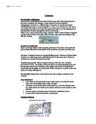
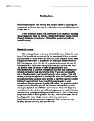
Flooding Essay. Describe and explain the physical and human causes of flooding and the possible solutions that may be undertaken to prevent flooding and to deal with it. There are many factors that contribute to the causes of flooding. These causes can either be human, (things that happen due to human life and civilisation) or physical, (things that happen naturally to cause flooding). Physical causes: The drainage basin is the area of which the river drains its water from. The boundaries are marked by the watershed. There are many different ways of which water can enter the river channel. Some ways are quicker that others. The quickest are examples like surface run-off. This happens when the rate of precipitation exceeds the rate of infiltration, so it flows over the top of the surface and into the river. The slowest ways for water to travel are groundwater flow. Precipitation has to infiltrate through the soil then pass horizontally through permeable rock and into the river. These can increase the risk of flooding as the water is getting to the river quicker. This will cause a mass excess of water to run into the river and flood its banks. Groundwater flow will stop water getting to the river channel quicker but it will eventually get there. Also if storage of water is held somewhere this can increase the risk of flooding. For example surface storage occurs when the

"What are the physical processes that cause geomorphic hazards? What problems do they cause for people?"
"What are the physical processes that cause geomorphic hazards? What problems do they cause for people?" The relationship between people and the terrain in which the live on, off and around has been closely co-dependent for thousands of years. In this essay I am aiming to discuss how and the reason how physical processes cause geomorphic hazards, including case studies around the world, where relevant, to show the causes and effects of such hazards. I also want to explain and describe how they have affected the everyday lives of millions of people in every corner of the World. Mass movement processes are the result of physical processes exerted by man (i.e. Farming methods) to natural processes (i.e. Earthquakes). When I talk about mass movement processes, this involves large masses or quantities of land material caused by a number of factors. The factors include: * Erosion by rivers, glaciers, or ocean waves create too steep slopes * Rock and soil slopes are weakened through saturation by snowmelt or heavy rains * Earthquakes create stresses that make weak slopes fail * Earthquakes of magnitude 4.0 and greater have been known to trigger landslides * Volcanic eruptions produce loose ash deposits, heavy rain, and debris flows. * Excess weight from accumulation of rain or snow, piling of rock or ore, from waste piles, or from man-made structures may stress weak
An Experiment to Investigate Species Diversity at West Runton Beach.
An Experiment to Investigate Species Diversity at West Runton Beach Aim For this investigation, I am aiming to investigate the species diversity at West Runton Beach. The aim is to research the distributions of substrates, plant life and other organisms, comparing them with each other and relating it to the tidal zonation. This will hopefully show us how each factor of the environment affects the others. The experiment will be a line transect using a quadrant down to parts of the beach; from the shore to the other end; by a groyne and down the middle. I hope also to see how this affects the ecology of the investigated areas. Objectives The objective of this experiment is to see how different factors of environments at this particular beach affect other factors. I intend to learn and gain a broader understanding about niches: which biotic and abiotic factors prefer which conditions. I also intend to see how the populations are structured. Apparatus In order to carry out this experiment we will need the following equipment: One metre squared quadrant A tape measure Pen and paper with clipboard Walking boots or Wellington boots Method To carry out this experiment I will need to maintain the following instructions: . We will do the following by the groyne and down the middle of the beach 2. I will gather all my equipment and make sure everything is prepared


