
B)Explain why the amount of solar radiation absorbed by the earth's surface varies from place to place and from time to time.
A)Define the terms insolation and albedo. Insolation is a combination of the phrase 'Incoming Solar Radiation'. It is the name for all energy which comes from the sun to the earth. The sun does not give out heat, but energy which is converted to heat when it reaches the earth. The albedo of an object is the measurement of how reflective it is against the sun. Snow will have a high albedo as is it is white and therefore a colour which reflects the sun's rays. Dark coloured surfaces such as a freshly ploughed field or rock will have a low albedo as it cannot reflect heat and will instead absorb it. It is also energy which goes straight back into space without having been converted into heat. B)Explain why the amount of solar radiation absorbed by the earth's surface varies from place to place and from time to time. The sun radiates solar energy which reaches the earth and is converted to heat. The location and time of this reaction, however, is variable due to the shape and tilt of the earth and the fact that it turns. This means that the energy reaches different places at different intensities at different times of day and different times of the year. This is dependent on many factors, not just those to do with the physical state of the earth. The shape, tilt and spin of the earth is the first factor which effects how much energy is absorbed by an area of earth. Due to the

Central Business District (Cbd) Investigation
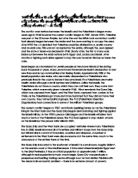
Introduction: The inner city is the zone between the central business district (CBD) and the suburban housing areas. In British cities the inner city grew during the industrial revolution. Factories were built on the edge of the historic towns, now the CBD. Many people view inner city areas as rather dull and depressing as they tend to be overcrowded and polluted. Unfortunately even though the problems of inner city areas are apparent the local councils and business and invested a greater proportion of money in CBD rather then inner cities, which has lead to an escalating problems. The Diagram illustrates the burgess conurbation model, which highlights the various areas of a conurbation settlement: The burgess model of urban land consists of five concentric circles arranged around a CBD inner core. All conurbation models initiates with the central business district (CBD), which forms the heart of a settlement. Large businesses exist here since they are the only ones able to afford the high land values and rents. The inner city is the 2nd zone in the burgess model. This zone represents old industry established at the birth of the city. The third zone is known as the "Low-class residential" which is located in the inner city close to the old industries. This was because the poor who worked in these industries had to be local. The medium class residential represents

Examine the factors influencing the movement of glaciers.
Examine the factors influencing the movement of glaciers. Glacier is defined as, 'a mass or river of ice moving very slowly'. Glaciers range in size considerably, Antarctica being the largest ice mass at 12.5 million km and a smaller ice mass of 12km existing in Africa. Glaciers move due to the force of gravity from areas of high altitude to lower areas. There are different mechanisms of glacial movement depending on the type of glacier. Cold (polar) glaciers are frozen to the underlying rock surface. These are found in high-latitude locations where the relief is low and basal temperatures are below the pressure melting point. Cold glaciers have very slow rates of movement, e.g. The Meserve glacier in Antarctica moves only 3-4 metres per year. Warm (temperate) glaciers on the other hand are not frozen to their bed. This type of glacier is found in high-altitude locations where the relief is steep and basal temperatures are at or near the pressure melting point. Temperate glaciers move very rapidly, e.g. The Franz Josef glacier in New Zealand moves approximately 300m per year. It is the basal temperature that determines the mechanism of movement. In what follows I will explain the factors influencing different mechanisms of movement. Temperate glaciers move mainly by basal sliding. If the basal temperature is at or above pressure melting point, a thin layer of meltwater

Evaluate the potential impact on individuals, communities and cultures of the changing retail structure of clone towns.
Evaluate the potential impact on individuals, communities and cultures of the changing retail structure of clone towns. Recently, the large number of chain stores around the UK has led to the creation of many “clone towns”: towns similar in appearance and atmosphere with the same shops as the rest of the country filling their high street. Naturally this shift in environments as places begin to lose their individuality and heritage affects everybody and has a great impact on individuals, communities and cultures. One benefit of these “clone towns” is that the increase in supermarket chains leads to consumers being able to choose from a wider selection of goods as they tend to stock more products than smaller, local shops which cannot afford to buy very large quantities of things. The fact that the supermarkets buy in bulk also means products are cheaper as they benefit from economies of scale. It is easy to say that one should support local, individual retailers, however if they cannot price competitively and offer all of the goods we need it’s natural for people to go to larger chain stores which meet their needs. Communities also benefit from increased employment opportunities provided by larger retail outlets which can afford to hire larger volumes of staff and provide additional employee benefits. For example, a large supermarket like Morrisons can afford to

Urban problems are the same the world over and require the same solutions To what extent do you agree with this view?
World Cities 'Urban problems are the same the world over and require the same solutions' To what extent do you agree with this view? Throughout the world there are many cities which have many different issues and have to solve them in a variety of different ways due to the economic, political, environmental and social states of the city itself. Therefore, I do not entirely agree with this view as many urban problems need different solutions in different cities. The biggest and most obvious differences are between LEDC's and MEDC's. These are at completely opposite ends of the spectrum when it comes to the ways they can deal with urban problems. Housing in the cities is one of the biggest problems in both of these kinds of cities, but in LEDC's such as Mexico City and Mumbai, it is much worse. Not only are these two of the most highly populated cities in the world, but they experience high polarisation between the CBD and outskirts of the city. This means living conditions and quality of life in the centre of the city are much better than those in the outskirts in most cases. The main housing problems stem from the overpopulation in the cities as people have nowhere to live so set up shanty towns and squatter settlements wherever space is available. This is why favelas in Mexico City have become such as a problem. As the cities are becoming a much more appealing place for
With reference to one recent major international conflict, access and analyse the geographical impacts of the conflict on the area(s) involved. Israel and Palestine.
'With reference to one recent major international conflict, access and analyse the geographical impacts of the conflict on the area(s) involved.' - 40 marks The conflict over territory between the Israeli's and the Palestinian's began many years ago in 1948 however the current conflict began in 1987. Before WW1, Palestine was part of the Ottoman Empire, but after the war the British took control but conflict had already begun between the Arabs and the Jews wanting to occupy the area. After WW2 the UN decided that Palestine would be divided into a Jewish country and an Arab one. This was not accepted by the Arabs, although the Jews agreed and the state of Israel was declared in 1948. Shortly after, the first of many wars broke out between the Arab nations (with Egypt and Jordan) and Israel. After months of fighting, both sides agreed to stop the war; however this has not been the case. Israel began as a homeland for Jewish people as they have historical ties dating back thousands of years. Many Jews moved there before Israel's declaration to start new lives and set up communities after fleeing Russia. Approximately 20% of the Israeli population are Arabs, who are mainly descendents of Palestinians who previously lived in the country before it became Israel. The Palestinians are mainly Muslim Arabs although a small number are Christians. Unlike the Israelis, the Palestinians
Britain's aging population
Britain's aging population Countries with aging populations have higher death rates. This is the case in the UK as death rates are particularly high in some of the popular retirement resorts along the south coast e.g. Brighton and Dorset. Although such services as the NHS work well in Great Britain and good doctors and medicine are keeping the elderly healthy until a much older age, this means that as the retirement age remains at sixty and people are beginning to live for longer. This is increasing the ratio of the number of people of working age (15-60\4 years) to support each person of sixty and over. As figure 3A and figure 3B show the UK to have the highest ratio against other high ratioed countries such as France. The figures show a forecast for the years to come, increasing by twenty years each time. Nearly all the way through the UK is shown to be the highest; this is due to the baby boom of the fifties and sixties. The official years of the Baby Boom Generation (1946 through 1964) saw a marked increase in the number of births in the world. Here's how the birth rate rose and fell during the baby boom years in America: 940 - 2,559,000 births per year 946 - 3,311,000 births per year 955 - 4,097,000 births per year 957 - 4,300,000 births per year 964 - 4,027,000 births per year 974 - 3,160,000 births per year There have even been books made about the baby boom:

Hengistbury Head is located in the south of England and has many prevention processes to prevent cliff erosion such as groynes, gabions and revetments.
HENGISTBURY HEAD COURSEWORK INTRODUCTION Hengistbury Head is located in the south of England and has many prevention processes to prevent cliff erosion such as groynes, gabions and revetments. GROYNES: wooden or stone structures on a beach, built at right angles to the shore in order to trap sand and shingle moving by longshore drift. GABIONS: small boulders contained inside metal cages, placed at the foot of the cliff or along a beach to protect them from further erosion. REVETMENTS: Large boulders placed at the foot of the cliff, used to protect a cliff against further erosion by waves. THE AIM OF THE PROJECT The main aim of the project at Hengistbury head is to investigate the management of Hengistbury Head by doing investigations on the physical and natural changes in the surroundings. We are also investigating the erosion and damage of the beach and cliffs and investigating what is being done to prevent this. On the first day of the project at Hengistbury Head, we have to investigate the physical and natural changes to the beach and cliff landscape. We have to investigate the usage of the land at Hengistbury Head, and mention all the physical features and coastal defences that are present at Hengistbury Head. We must also note down all the human features present at the location such as management, archaeological sites, footpaths, car parks and cafes. We must also
Explain where and why depositional landforms occur along the course of a river.
Explain where and why depositional landforms occur along the course of a river. Rivers have three courses. The course is the journey the river makes to reach the sea. Rivers never have a straight course from source to mouth. Their course is always irregular. Along this course depositional landforms can occur. Landforms can be formed from the deposition of weathered and eroded surface materials. On occasion, these deposits can be compressed, altered by pressure, heat and chemical processes to become sedimentary rocks. This includes landforms with some of the following geomorphic features: beaches, deltas, floodplains, and glacial moraines. The upper course is found in the mountains and hills where the river rises from its source and often waterfalls and rapids are also found in this course. The river is usually fast flowing in the upper course; also there are lots of stones and boulders for the water to flow over. Furthermore, the river starts as a stream in the upper course and flows through valleys. The middle course, however, is where the river starts to become wider and deeper. The land, which the river flows over, is becoming flatter and this is where the river starts to meander or bend in the middle course. The lower course is where the river becomes its widest and deepest. This course is found closest to the sea where the river has its mouth. The flat area of land by

Discuss the view that poverty is the real killer in earthquake disasters
Discuss the view that poverty is the real killer in earthquake disasters. (40 marks) Seismic events prove that it is a problematic for the world's population and produce devastating effects on the lives of everyone involved. However it is often said that LEDCs suffer much more from the effects of earthquakes than MEDCs. Whilst this is a generalisation it is probably true, at least in terms of the human cost. Poverty is the condition of lacking basic human needs such as nutrition, clean water, health care, clothing, and shelter because of the inability to afford them. There are several levels of poverty from an individual to national level and earthquake disasters impact at all levels. The 2010 Haiti earthquake struck in the most densely populated area of the country, As More than 78% per cent of Haitian residents live in poverty and Haiti is the poorest country in the Western Hemisphere the buildings in Port-Au-Prince and other areas of Haiti were in very poor condition in general and were not designed or constructed to be earthquake resistant. The primary earthquake hazard directly responsible for mortality is surface seismic waves which cause ground shaking. This poses a huge hazard as buildings and other structures collapse, killing or injuring their occupants. This was the case in Sichuan, China in 2008 where severe ground shaking was the direct cause of death, injury


